Tag Archives: emigration

Showing migration flows

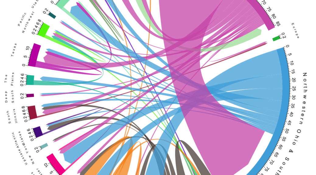
The migration flows of the Bührers lend itself to visualisation with a chord plot, done with R‘s circlize package after a post by Guy Abel.

Bührer migration flows

The plot shows migration flows between regions as well as flows within a region that exceed 200 km. “Regions” are essentially place clusters that have been visually identified on the map. It includes all persons born as Bührer (“Named”) from the dataset, where migration can be inferred based on georeferenced events. Note that a particular person can feature in several flows, e.g. first emigrating to northwestern Ohio with a subsequent migration to Kansas.

In contrast to my maps – that only show the United States – you can also see that some Bührers emigrated to Brazil (around Curitiba) as well as India (Mangalore). Either migration is likely to predate the known emigration to the United States.

Plotting the map’s family tree

The – with 13 A3 pages very wide – family tree (Family Tree of Emigrated Buehrers) shows all persons that emigrated to the United States including their ancestors as well as their immediate relatives. Persons are aligned horizontally by generation, with oldest generations on the top. Squares denote males, circles females and triangles marriages. Persons represented by black line symbols are shown on the map whereas those with grey line symbols are not. Otherwise symbology follows the one for the map, i.e. line styling indicates category and colours show common male ancestors.

Family Tree of Emigrated Buehrers - Detail
Detail of the family tree of emigrated Bührers

Data for the family tree was prepared in the project’s PostgreSQL database stripping irrelevant persons and families. The family tree was drawn in yEd (http://www.yworks.com) in “Family Tree” mode and styled via Properties Mapper.

Mapping the Emigration of the Bührers from Switzerland to the United States

In the second half of the 19th century many farmers emigrated from the rural communities of the Swiss canton of Schaffhausen, mainly due to a local agricultural crisis and better economic prospects elsewhere. There were emigration peaks around 1850, 1870 and in the 1880’s with a large majority of emigrants heading to the United States. From 1868 to 1890 an equivalent of more than 10% of the canton’s population had left, a large number for Swiss standards at the time.

Among the emigrants were many Bührers from the small hamlets of Bibern, Hofen, Opfertshofen as well as from Herblingen and Stetten in the Reiat region. Originally immigrated from southern Germany the Swiss Bührer at large remained constrained to that tiny corner of Switzerland, which greatly facilitates genealogical research.

Emigration of Buehrer to the United States - Map 1
Emigration of Buehrer to the United States – Map 1

The maps shows the Bührers’ emigration to the United States (Map 1) up to the 1880s and subsequent internal migration up to now (Map 2). Almost all of them initially immigrated to a small area in northwestern Ohio around the city of Archbold in Fulton County; some of them migrated further west to Kansas, Texas or the Pacific Northwest.

In order to provide the necessary historic context Map 1 shows historic state boundaries, population density as well as the railway network (the main mode of transportation for Swiss emigrants) at 1870, the heyday of the Bührer emigration.

Emigration of Buehrer to the United States - Map 2
Emigration of Buehrer to the United States – Map 2

A legend explains the symbology.